ดาวน์โหลดงานนำเสนอ
งานนำเสนอกำลังจะดาวน์โหลด โปรดรอ

1
Shipment via Man-made Canal and Strait
Special Scoop

2
Oil Logistic Channel

3
Man-made Canal คลองขุดที่มีชื่อเสียงด้านโลจิสติกส์ ระดับโลก Suez
Panama Thai (คลองที่ควรเกิดหรือไม่) คลองกระ คลองสยาม
 คลองกระ. คลองสยาม.")
4
The dream of a canal across the Isthmus of Suez had existed since the time 4,000 years ago when the pharaohs built Egypt's first canal. (It linked the Nile River with the Great Bitter Lake, which then opened onto the Gulf of Suez.) This canal, however, was filled in, and for centuries trade with the Far East was carried overland across Asia. Eventually ships began to sail around the southern tip of Africa to reach the Mediterranean Sea from the Red Sea. .
 This canal, however, was filled in, and for centuries trade with the Far East was carried overland across Asia. Eventually ships began to sail around the southern tip of Africa to reach the Mediterranean Sea from the Red Sea. ..")
5
SUEZ Canal Then in 1858 a French engineer, Ferdinand de Lesseps, acquired the rights from his friend, Said Pasha, viceroy of Egypt, to organize a company and build a canal. On November 17, 1869, the Suez Canal was opened with great ceremony at the northern terminus, Port Said, which was named for Said Pasha. The 12,400-mile (19,950-kilometer) voyage from London around South Africa to Bombay, India, was shortened to 7,250 miles (11,670 kilometers).
 voyage from London around South Africa to Bombay, India, was shortened to 7,250 miles (11,670 kilometers).")
6
SUEZ Canal Port Said Town

7
The Suez Canal is 101 miles (163 kilometers) long, or about twice the length of the Panama Canal. The Suez was easier to construct because it crosses flat, sea-level terrain and requires no locks. About 24 miles (39 kilometers) of the canal are channels dredged through lakes. Most of the banks of the other 77 miles (123 kilometers) are reinforced with stone, cement, or steel to help prevent erosion
 of the canal are channels dredged through lakes. Most of the banks of the other 77 miles (123 kilometers) are reinforced with stone, cement, or steel to help prevent erosion.")
8
SUEZ Canal

10
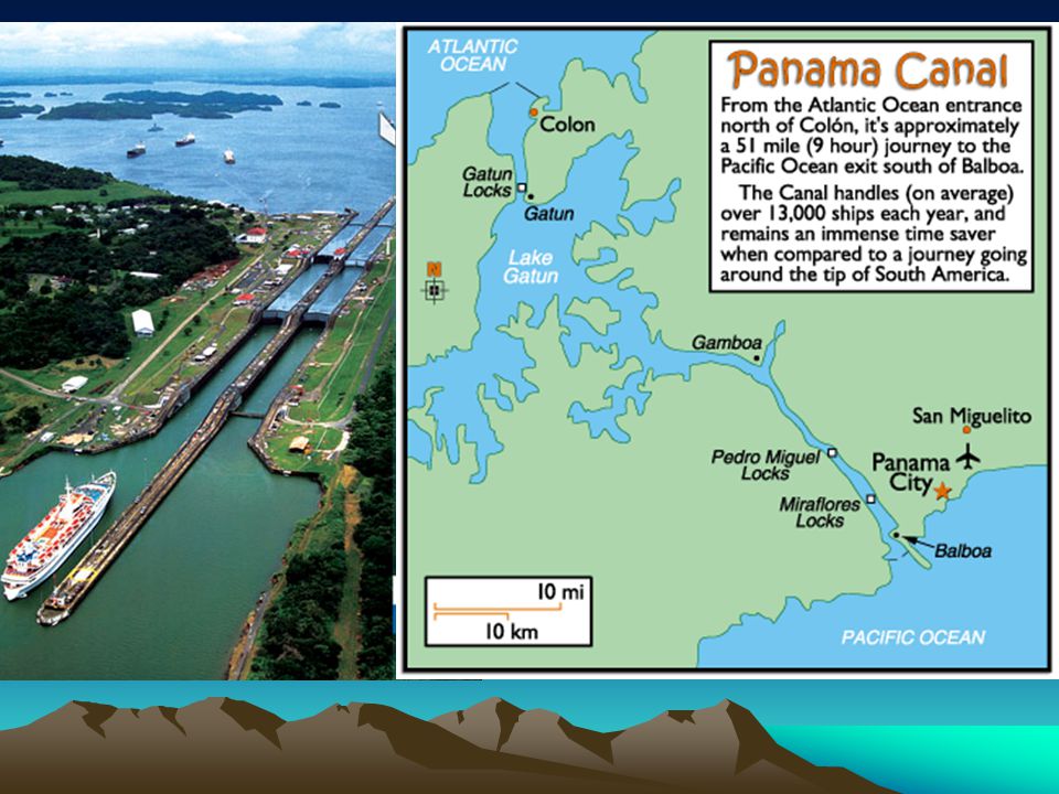
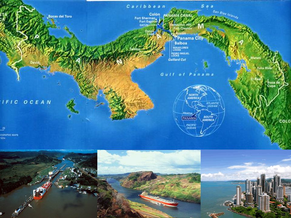
Panama Canal The Panama Canal extends across the Isthmus of Panama from Colon on the Atlantic Ocean (Caribbean Sea) side to Balboa and the Pacific Ocean. The canal was constructed in two stages. The first between 1881and 1888 by a French company, then followed by the Americans, with their construction completed in 1914.
 side to Balboa and the Pacific Ocean. The canal was constructed in two stages. The first between 1881and 1888 by a French company, then followed by the Americans, with their construction completed in")
11
Panama Canal In 1883 it was realized that the tide level at the Pacific side was almost 19 feet higher than the Atlantic side. Engineers concluded the difference in levels would be a danger to navigation. It was then proposed that a tidal lock should be constructed near Panama City to preserve the level from there to Colon.

14
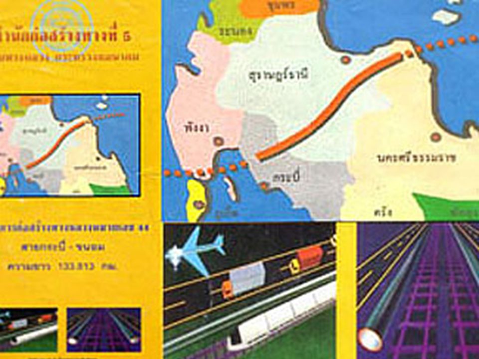
คลองไทย (คลองกระ) คลองกระ เป็นคลองที่จะขุดขึ้น เพื่อเชื่อมทะเลอันดามัน กับอ่าวไทย มีความยาวประมาณ 102 กิโลเมตร กว้าง 450 เมตร ลึก 20 เมตร คาดว่าสามารถรองรับเรือผ่านคลองได้ราว 40 ลำต่อวัน (ดูตารางเปรียบเทียบกับคลองอื่นๆในลักษณะเดียวกัน) - ค่าขุดคลองโดยใช้วิธีการขุดปกติ ใช้เงินลงทุน 814,448 ล้านบาท ระยะเวลาขุด ปี หรือถ้าขุดโดยใช้ระเบิดนิวเคลียร์ จะใช้เงินลงทุน 435,849 ล้านบาท ระยะเวลาขุด 8-13 ปี - ประมาณการรายรับ แบ่งออกเป็น รายได้จากค่าผ่านคลอง และรายได้จากการพัฒนาเขตอุตสาหกรรมบริเวณข้างคลอง ในสัดส่วน 80:20 โดยอยู่บนสมมุติฐานที่ว่า ช่องแคบมะละกาถูกปิด และเรือจะวิ่งมาผ่านคลองกระแทน จำนวน ลำต่อปี โดยเป็นเรือบรรทุกน้ำมันจะมีสองขนาดคือ ตัน และ ตัน อย่างละ 50% โดยคิดค่าผ่านทางเฉลี่ย ที่ตันละ เหรียญสหรัฐต่อตัน - ค่าใช้จ่ายของเรือ สำหรับเรือบรรทุกน้ำมันขนาด 250,000 ตัน คิดอยู่ที่ $70,800 US ต่อวัน - โครงการขุดคลองกระ เป็นโครงการที่เริ่มขุดทำแล้วต้องขุดให้เสร็จ มิฉะนั้นจะไม่ได้รับผลตอบแทน เลย โดยหากขุดแล้ว ไม่ขุดให้สำเร็จ จะเป็นการลงทุนที่เกือบจะเรียกได้ว่า สูญเปล่า ใช้ประโยชน์อย่างอื่นแทบไม่ได้เลย - การขุดคลอง ยังไม่ได้มีการศึกษาผลกระทบในเชิงนิเวศน์ รวมถึงการศึกษาแผนพัฒนาเขตอุตสาหกรรมเกี่ยวเนื่องในเขตบริเวณคลอง ซึ่งจากผลการดำเนินงานของคลองอื่นๆที่ได้มีการขุดไปแล้ว พบว่า เขตอุตสาหกรรมในบริเวณคลอง ไม่ประสบผลสำเร็จในเชิงเศรษฐกิจ
 - ค่าขุดคลองโดยใช้วิธีการขุดปกติ ใช้เงินลงทุน 814,448 ล้านบาท ระยะเวลาขุด ปี หรือถ้าขุดโดยใช้ระเบิดนิวเคลียร์ จะใช้เงินลงทุน 435,849 ล้านบาท ระยะเวลาขุด 8-13 ปี - ประมาณการรายรับ แบ่งออกเป็น รายได้จากค่าผ่านคลอง และรายได้จากการพัฒนาเขตอุตสาหกรรมบริเวณข้างคลอง ในสัดส่วน 80:20 โดยอยู่บนสมมุติฐานที่ว่า ช่องแคบมะละกาถูกปิด และเรือจะวิ่งมาผ่านคลองกระแทน จำนวน ลำต่อปี โดยเป็นเรือบรรทุกน้ำมันจะมีสองขนาดคือ ตัน และ ตัน อย่างละ 50% โดยคิดค่าผ่านทางเฉลี่ย ที่ตันละ เหรียญสหรัฐต่อตัน - ค่าใช้จ่ายของเรือ สำหรับเรือบรรทุกน้ำมันขนาด 250,000 ตัน คิดอยู่ที่ $70,800 US ต่อวัน - โครงการขุดคลองกระ เป็นโครงการที่เริ่มขุดทำแล้วต้องขุดให้เสร็จ มิฉะนั้นจะไม่ได้รับผลตอบแทน เลย โดยหากขุดแล้ว ไม่ขุดให้สำเร็จ จะเป็นการลงทุนที่เกือบจะเรียกได้ว่า สูญเปล่า ใช้ประโยชน์อย่างอื่นแทบไม่ได้เลย - การขุดคลอง ยังไม่ได้มีการศึกษาผลกระทบในเชิงนิเวศน์ รวมถึงการศึกษาแผนพัฒนาเขตอุตสาหกรรมเกี่ยวเนื่องในเขตบริเวณคลอง ซึ่งจากผลการดำเนินงานของคลองอื่นๆที่ได้มีการขุดไปแล้ว พบว่า เขตอุตสาหกรรมในบริเวณคลอง ไม่ประสบผลสำเร็จในเชิงเศรษฐกิจ.")
16
การขุดคลองไทย http://www.thai-canal.com/index.php
การขุดคลองไทย

18
การย่นระยะทางจากการเดินทางผ่านช่องแคบมะละกาเดิม มาใช้บริการคลองไทยจะทำให้ประหยัดการเดินเรือไปได้มากมาย

19
Strait of Malaka

20
Strait of Malaka

21
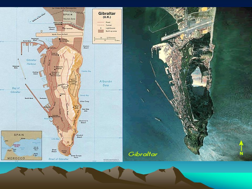
Strait of Gibraltar This perspective view shows the, which is the entrance to the Mediterranean Sea from the Atlantic Ocean. Europe (Spain) is on the left. Africa (Morocco) is on the right. The Rock of Gibraltar, administered by Great Britain, is the peninsula in the back left.
 is on the left. Africa (Morocco) is on the right. The Rock of Gibraltar, administered by Great Britain, is the peninsula in the back left. img_id=")
23
Rock of Gibraltar Strait of Gibraltar

24
Gibraltar

งานนำเสนอที่คล้ายกัน