ดาวน์โหลดงานนำเสนอ
งานนำเสนอกำลังจะดาวน์โหลด โปรดรอ

1
รองศาสตราจารย์ ดร.เลิศชัย เจริญธัญรักษ์
การประเมิน Appraisal [Risk Assessment] รองศาสตราจารย์ ดร.เลิศชัย เจริญธัญรักษ์ Dr.rer.nat (Env Health Sc), Univ.of Innsbruck, Austria Cert. in Field Epidemiology, Env & Occ Epid วท.ม. (วิทยาศาสตร์สิ่งแวดล้อม), ป.บัณฑิต (วิศวกรรมสุขาภิบาล), วท.บ. (เคมี) คณะสาธารณสุขศาสตร์ มหาวิทยาลัยขอนแก่น 3 ก.พ.2552 รร.เอเชีย แอร์พอร์ต
, Univ.of Innsbruck, Austria. Cert. in Field Epidemiology, Env & Occ Epid. วท.ม. (วิทยาศาสตร์สิ่งแวดล้อม), ป.บัณฑิต (วิศวกรรมสุขาภิบาล), วท.บ. (เคมี) คณะสาธารณสุขศาสตร์ มหาวิทยาลัยขอนแก่น. 3 ก.พ.2552 รร.เอเชีย แอร์พอร์ต.")
2
What is meant an appraisal ?
Critical state for decision making carefully examine the report submitted by Consultant for Quality Control Verify or Approve the work done (reject or accept) Definition: An appraisal is about considering, evaluating and interpreting information in a systematic and objective way.
 Definition: An appraisal is about considering, evaluating and interpreting information in a systematic and objective way.")
3
(Env.) Health Impact Assessment
ระยะการก่อสร้าง ก่อนดำเนินการ สถานการณ์ทางสุขภาพ โครงการ หลังดำเนินการ -Vital Statistics -Diseases -Nutrition Status -Sanitary -Occupational Health & Safety -Health Resources and Personnel -Vectors & Carriers (Agent & Env) -etc. ระยะดำเนินการ Prediction Evaluatuon Mitigation
 -etc. ระยะดำเนินการ. Prediction. Evaluatuon. Mitigation.")
4
The (E)HIA study concepts
The (E)HIA study attempts to answer five questions: i) What will happen as a result of the project? ii) What will be the extent of the changes? iii) Do the changes matter? iv) What can be done about them? v) How can decision-makers be informed of what needs to be done? Identification Prediction Evaluation Mitigation Documentation
HIA study attempts to answer five questions: i) What will happen as a result of the project ii) What will be the extent of the changes iii) Do the changes matter iv) What can be done about them v) How can decision-makers be informed of what. needs to be done Identification. Prediction. Evaluation. Mitigation. Documentation.")
5
Evaluation concepts To evaluate “ Do the changes matter? ”, this judgment of significance can be based on one or more of the following : Comparison with laws, regulation or accepted standards Consultation with the relevant decision-makers Reference to pre-set criteria such as protected sites, features or species consistency with government policy objectives Acceptability to the local community or the general public.

6
Mitigation Changing project sites, routes, processes, raw materials, operating methods, disposal routes or locations, timing or engineering designs Introducing pollution controls, waste treatment, monitoring, phased implementation, landscaping, personnel training, special social services or public education Offering (as compensation) restoration of damaged resources, money to affected persons, concessions on other issues, or off-site programs to enhance some other aspect of the environment or quality of life for the community.
 restoration of damaged resources, money to affected persons, concessions on other issues, or off-site programs to enhance some other aspect of the environment or quality of life for the community.")
7
Background to Risk Assessment
Risk is the probability that a particular adverse event occurs during a stated period of time, or results from a particular event. A hazard is an act or phenomenon posing, potential harm to some persons or things

8
What is Risk ? The answer to this is found in the answers to the questions – What can go wrong? – the Hazard How likely is it to happen? – the Probability What will happen ? – the Consequences This tells us the difference between the likelihood for harm -Hazard (where there is no time base) and Risk – what harm is likely to happen (where there is a time base)
 and Risk – what harm is likely to happen (where there is a time base)")
9
There are many examples of public health impacts from environmental hazards
SO2 in Thailand (Mae Moh Lignite Mine, Lampang) Arsenic in Bangladesh, Taiwan & Chile, Thailand Cadmium in Mae Sod, Tak, Thailand Lead in Kity, Thailand Melamine in Milk from China VOC in Rayong Province Lead from car exhausts, smelter operations PM10 in Chaingmai Province
 Arsenic in Bangladesh, Taiwan & Chile, Thailand. Cadmium in Mae Sod, Tak, Thailand. Lead in Kity, Thailand. Melamine in Milk from China. VOC in Rayong Province. Lead from car exhausts, smelter operations. PM10 in Chaingmai Province.")
10
สาระสำคัญของรายงานEIA
สภาพสิ่งแวดล้อมในปัจจุบัน(Existing Environmental Conditions) ทรัพยากรสิ่งแวดล้อมทางกายภาพ (Physical Resources) ทรัพยากรสิ่งแวดล้อมทางชีวภาพ (Ecological [Biological] Resources) คุณค่าการใช้ประโยชน์ของมนุษย์ (Human use Values) คุณค่าต่อคุณภาพชีวิต (Quality of Life Values)
 ทรัพยากรสิ่งแวดล้อมทางกายภาพ. (Physical Resources) ทรัพยากรสิ่งแวดล้อมทางชีวภาพ. (Ecological [Biological] Resources) คุณค่าการใช้ประโยชน์ของมนุษย์ (Human use Values) คุณค่าต่อคุณภาพชีวิต. (Quality of Life Values)")
11
ทรัพยากรสิ่งแวดล้อมทางกายภาพ (Physical Resources)
ภูมิสัณฐาน ลักษณะภูมิประเทศ ระดับความสูง ลักษณะที่โดดเด่นเฉพาะทางกายภาพ เช่น เกาะ หน้าผา ฯลฯ ดิน ชนิดประเภท สัดส่วน กษัยการของดิน การตกตะกอน คุณสมบัติ กายภาพ เคมี ชีวภาพ สมรรถนะและศักยภาพของดิน ธรณีวิทยา ลักษณะทางธรณีวิทยา การเกิดแผ่นดินไหว ทรัพยากร แหล่งแร่ธาตุ ชนิด ปริมาณแร่ธาตุในพื้นที่และบริเวณใกล้เคียง น้ำผิวดิน/น้ำใต้ดิน แหล่งน้ำ ปริมาณน้ำ คุณภาพน้ำ อัตราการไหล น้ำทะเล ลักษณะทางสมุทรศาสตร์ คุณภาพน้ำ การหมุนเวียนของน้ำ การแบ่งชั้นของน้ำ อากาศ ภูมิอากาศ ปริมาณฝน ความชุก อุณหภูมิ ปรากฏการณ์ชั้นอุณหภูมิผกผัน หมอก พายุ คุณภาพอากาศ เสียง ระดับความเข้มของเสียง ความถี่

12
ทรัพยากรสิ่งแวดล้อมทางชีวภาพ (Ecological Resources)
สัตว์/พืช นิเวศวิทยา ชนิด ปริมาณ การแพร่กระจาย สิ่งที่มีชีวิตที่หายาก ความสำคัญ

13
คุณค่าการใช้ประโยชน์ของมนุษย์ (Human use values)
น้ำดื่ม/น้ำใช้ แหล่งน้ำ ปริมาณ คุณภาพ ความเพียงพอ การขนส่ง เส้นทางคมนาคม ทางหลวง ทางรถไฟ ทางน้ำ ไฟฟ้าและพลังงาน แหล่งที่มา ชนิด ประเภท ความเพียงพอ การควบคุมน้ำท่วม/การระบายน้ำ ระบบการควบคุม ประสิทธิภาพ การเกษตรกรรม การพัฒนาการเกษตร การเพาะเลี้ยงสัตว์น้ำ การชลประทาน การปลูกป่า การอุตสาหกรรม ลักษณะการทำอุตสาหกรรม เหมืองแร่ ลักษณะการทำเหมืองแร่ สันทนาการ รูปแบบ ลักษณะการใช้พื้นที่สันทนาการ พื้นที่พักผ่อนหย่อนใจของสาธารณะ พื้นที่สีเขียว การใช้ที่ดิน สภาพการใช้ประโยชน์ที่ดิน การกำหนดพื้นที่เฉพาะ

14
คุณค่าต่อคุณภาพชีวิต (Quality of Lifes)
เศรษฐกิจสังคม ข้อมูลประชากร อาชีพ รายได้ ภาษา ศาสนา ฯลฯ การตั้งถิ่นฐาน ทัศนคติประชาชนที่มีต่อโครงการ การสาธารณสุข อัตราการเจ็บป่วย ตาย โรคระบาด โรคประจำถิ่น สถิติชีพ การบริการทางสาธารณสุข อาชีวอนามัย โรคจากการทำงาน อุบัติเหตุจาการทำงาน ลักษณะงาน ความเสี่ยง การเตรียมพร้อมกับเหตุ ประวัติศาสตร์ โบราณสถาน โบราณวัตถุ โบราณคดี ขนบธรรมเนียมประเพณี วัฒนธรรมดั้งเดิม สุนทรียภาพ คุณค่าความงดงามของแหล่งท่องเที่ยว สถานที่สำคัญทางธรรมชาติ แหล่งธรรมชาติอันควรอนุรักษ์

15
ตัวอย่างข้อมูลรายละเอียดโครงการอุตสาหกรรม
สถานที่ตั้งและขนาดของโครงการ แผนผังต่างๆ วัตถุดิบ ชนิด แหล่งที่มา คุณสมบัติ ความเป็นพิษ การขนถ่าย การจัดเก็บ ผลิตภัณฑ์ ผลผลิต ชนิด ปริมาณ จำนวน อัตราการผลิต จำหน่าย การขนส่งวัตถุดิบ และผลผลิต กระบวนการผลิต รายละเอียดต่างๆ ภาวะมลพิษที่เกิดจากกระบวนการผลิตและระบบควบคุม พลังงาน แสดง ชนิด ปริมาณ แหล่งพลังงานต่างๆ พนักงาน จำนวน ระดับคนงาน เจ้าหน้าที่ ที่พัก ทุกระดับ เวลา ระบบเสริมและระบบสาธารณูปโภค ปริมาณน้ำใช้/ดื่ม น้ำทิ้ง น้ำฝน ระบบไฟฟ้า แหล่ง ปริมาณ กำลังไฟฟ้าที่ใช้ เทคโนโลยีการลดหรือการจัดการของเสีย อาชีวอนามัยและความปลอดภัย การจัดให้มีพื้นที่สีเขียว นันทนาการ

16
Principle of Assessment
Community cooperation is essential in profiling, especially with regard to providing personal medical information where it is relevant. Baseline or background health information is useful in determining changes in the original health profile of workers and communities within the impact area of development project through time.

17
Principle of Assessment
Baseline health information can be obtained from secondary data sources available in the municipal as well as provincial health offices. Primary data may be collected through surveys of impact communities in cases where secondary data are insufficient to provide an accurate health profile of affected communities.

18
Baseline information which contributes to profiling
Characteristics of the existing and incoming populations of the region including size, age structure, socioeconomic status, population at risk Physical characteristics of the region, such as frequency of atmospheric inversion, variability of river flow, orientation of prevailing winds, water tables, geological stability

19
Baseline information which contributes to profiling
Existing land uses, especially those that can be considered incompatible with or inappropriate to the proposed development Current health status of the population including morbidity, mortality, and social and psychological health indicators. Current levels of pollutants and environmental degradation.

20
Baseline information which contributes to profiling
Existing data and studies concerning the types of problems likely to arise from the development project or policy. The reliability of these data needs to be carefully considered, especially if they relate to a region or population which differs from that for which EHIA is being carried out. Existing standard of living of the population especially in relation to factors such as access to water supplies, adequacy of diet, and access to health facilities.

21
Minimum dataset for industrial development proposals
Best available quantitative description of diseases related to pollutants associated with the development project. Best available quantitative description of the dispersive, absorptive and adsorptive mechanisms in air, water and soil. Information on concentrations of the pollutants over the various periods of time to which the affected population groups, including workers, will be exposed.

22
Minimum dataset for industrial development proposals
Information on environmental, social and economic factors which are likely to influence the susceptibility of the affected population. Forecasting of health effects including their intensity, duration, and lag time between exposure and effect. Assessment of short- and long-term health impacts.

23
Minimum dataset for industrial development proposals
Identification of and the means by which the health effects could be eliminated or reduced. Assessment of the health impacts of alternatives. Definition of the health monitoring system to be instituted together with the activities of the proposed project.

24
Principle of Assessment
Compilation of baseline data Identification of impacts Prediction of the magnitude of the changes Determination of the significance of the impacts

25
What is health impact? The predicted change from natural “baseline” state resulting from a particular activity adverse or beneficial both temporal and spatial dimensions primary (direct) or secondary (indirect) cumulative effects possible from combination with existing developments need to consider lifetime of project
 or secondary (indirect) cumulative effects possible from. combination with existing developments. need to consider lifetime of project.")
26
Evaluation of health impact
Serious negative impact Very significant negative impact Significant negative impact Minor negative impact No negative impact (Positive impact)
")
27
Aims of assessment (prediction)
when impact will occur area which impact will affect magnitude of the impact significance of predicted changes certainty of prediction limitations of techniques and data used

28
Prediction and assessment
E.g. air quality impact prediction Prediction of dispersal of plumes of pollutants achieved by use of computer models

29
Principles of assessing the interaction between environment & health
Alternative/complementary approaches Epidemiology Health Risk Assessment

32
Differences between epidemiology
and risk assessment item Epidemiology Risk assessment Objective Estimation, Assessing causality Prediction Fundamental measures Relative risk, Odds ratios Absolute or excess risk Population of interest Study population Overall population Validity issues Internal validity External validity

33
ad hoc - briefing, consultation and workshop methods Index approaches
Impact identification/presentation methods A number of techniques have been developed for the presentation of (env) health impacts results to decision-makers and the general public. ad hoc - briefing, consultation and workshop methods Index approaches (matrixes and checklists) Overlays (GIS) Networks Systems diagrams, Cost-benefit analysis (systems analysis) Simulation modeling workshops
 health impacts results to decision-makers and the general public. ad hoc - briefing, consultation and. workshop methods. Index approaches. (matrixes and checklists) Overlays (GIS) Networks. Systems diagrams, Cost-benefit analysis. (systems analysis) Simulation modeling workshops.")
34
วิธีการประเมิน การตั้งคณะกรรมการเฉพาะกิจ (Ad hoc committee approach)
การเช็ครายการ (Checklist) การใช้เมตริกซ์ (Matrices) การใช้แผนภาพซ้อน (Overlays) การวิเคราะห์แบบสายใยเชื่อมโยงความสัมพันธ์กัน (Networks) การใช้แบบจำลองทางคณิตศาสตร์ (Simulation [mathematical] modelling) *ขบวนการมีส่วนร่วม* (Participation)
 การใช้เมตริกซ์ (Matrices) การใช้แผนภาพซ้อน (Overlays) การวิเคราะห์แบบสายใยเชื่อมโยงความสัมพันธ์กัน. (Networks) การใช้แบบจำลองทางคณิตศาสตร์ (Simulation [mathematical] modelling) *ขบวนการมีส่วนร่วม* (Participation)")
35
Briefing / brainstorming approaches to
Briefing, consultation and workshops “ad hoc” This method gives broad qualitative information which is of value in comparing alternative development sites or schemes. This information is stated in simple terms readily understandable by a lay decision-maker or member of the public, and avoids outlining the actual impacts on the specific parameters which will be affected. Briefing / brainstorming approaches to scoping frequently used - relies on experience and knowledge of the assessment team Consultation with interested groups and statutory consultees Public participation

36
การตั้งคณะกรรมการเฉพาะกิจ (Ad hoc committee approach)
เป็นวิธีการเชิญผู้เชี่ยวชาญสาขาต่างๆมาร่วมพิจารณา เพื่อจะประเมินผลกระทบของโครงการนั้นๆ เปรียบเทียบข้อดี ข้อเสีย พิจารณาทางเลือกต่างๆ จะทำให้ได้ข้อมูลแนวความคิดผลกระทบทางคุณภาพที่เป็นไปได้อย่างกว้างๆ วิธีนี้อาจทำให้ได้ข้อมูลผลกระทบที่สำคัญไม่ทั้งหมด การกำหนดเกณฑ์หรือข้อกำหนดที่แตกต่างกันในกลุ่ม/คณะผู้เชี่ยวชาญ ทำให้การวิเคราะห์นั้นอาจจะขาดความหนักแน่นไม่มีประสิทธิภาพ เนื่องจากบางครั้งพยายามที่จะแจกแจงรายละเอียดสำหรับการประเมินผลกระทบแต่ละหัวข้อมากหรือน้อยเกินไป ไม่สามารถบอกได้ชัดเจนว่าความเข้าใจในแต่ละผลกระทบในแต่ละประเด็นเหมือนกันหรือไม่

37
Ad hoc method Benefits relatively cheap in terms of time and resources universially applicable experience and expertice of practitioner simulation approach used for rapid assessments Disadvantages No assurance that a comprehensive set of impacts will be identified difficulty of arriving at consensus and risk for inconsistencies number of participants limited

38
การตั้งคณะกรรมการเฉพาะกิจ (Ad hoc committee approach)
ตัวอย่างที่ใช้วิธี Ad hoc เพื่อเลือกที่ตั้งของเขื่อนและอ่างเก็บน้ำระหว่าง A B และ C โดย กรณี A และ B เป็นโครงการก่อสร้างเขื่อน และอ่างเก็บน้ำในลำน้ำ จำนวน 4 และ 1 แห่ง ตามลำดับ ส่วน กรณี C เป็นกรณีที่ไม่มีโครงการ หัวข้อ ทางเลือก A B C จำนวนอ่างเก็บน้ำตามลำน้ำ พื้นที่ผิวอ่างเก็บน้ำ (ไร่) รวมระยะชายฝั่งอ่างเก็บน้ำ (กม.) พื้นที่ชลประทานใหม่ (ไร่) พื้นที่ที่ถูกน้ำท่วม จำนวนแหล่งโบราณคดีที่ถูกผลกระทบ (แห่ง) ปัญหาการชะล้าง/พังทลายของดิน(ปริมาณเปรียบเทียบ) การประมงที่เพิ่มขึ้น (ปริมาณเปรียบเทียบ) การช่วยป้องกันน้ำท่วม การเพิ่มโอกาสการเกิดโรคมาลาเรีย (ปริมาณเปรียบเทียบ) จำนวนศักยภาพคนงานที่จะจ้างเพิ่ม(จำนวนคน) 4 8,500 190 40,000 10,000 11 4x Yes 1,000 1 1,300 65 12,000 2,000 3 1x 200 - Nil No
 รวมระยะชายฝั่งอ่างเก็บน้ำ (กม.) พื้นที่ชลประทานใหม่ (ไร่) พื้นที่ที่ถูกน้ำท่วม. จำนวนแหล่งโบราณคดีที่ถูกผลกระทบ (แห่ง) ปัญหาการชะล้าง/พังทลายของดิน(ปริมาณเปรียบเทียบ) การประมงที่เพิ่มขึ้น (ปริมาณเปรียบเทียบ) การช่วยป้องกันน้ำท่วม. การเพิ่มโอกาสการเกิดโรคมาลาเรีย (ปริมาณเปรียบเทียบ) จำนวนศักยภาพคนงานที่จะจ้างเพิ่ม(จำนวนคน) 4. 8, , , x. Yes. 1, , ,000. 2, x Nil. No.")
39
Checklists method simple checklists descriptive checklists
Checklist present a specific list of environmental health parameters to be investigated for possible impacts. They do not require establishing cause -effect links to project activities. simple checklists descriptive checklists questionnaire checklists weighting-scaling checklists

40
การเช็ครายการ (Checklist)
เป็นวิธีการกำหนดค่าตัวแปรเฉพาะของแต่ละสิ่งแวดล้อมมาใช้เพื่อตรวจสอบผลกระทบที่อาจเป็นไปได้ โดยพิจารณาผลกระทบที่คาดว่าจะเกิดจากโครงการ โดยพิจารณาแจกแจงว่าเป็นผลกระทบที่เป็นผลเสียหรือผลดี เป็นผลกระทบที่เกิดขึ้นในระยะสั้นหรือระยะยาว เป็นผลกระทบที่แก้ไขให้กลับคืนมาได้หรือไม่ได้ ตลอดจนผลกระทบที่เกิดขึ้นเป็นบริเวณหรือมีการแพร่กระจายไปอย่างกว้างขวาง ไม่ได้ต้องการความสัมพันธ์ระหว่างสาเหตุและผลกระทบในกิจกรรมของโครงการ อาจจะบอกหรือไม่ต้องบอกถึงวิธีการวัดและการแปรผลมากนัก อย่างไรก็ตามวิธีการเช็ครายการอย่างกว้างๆพื้นฐานที่ใช้กันอย่างใดอย่างหนึ่งใน 4 แบบ ดังนี้ Simple checklist มีรายชื่อของตัวแปร ไม่ต้องการตัวชี้วัดวิธีการวัดตัวแปร Descriptive checklist การพรรณนาแจกแจงตัวแปรสิ่งแวดล้อม ชี้วิธีการวัดตัวแปร Scaling checklist เหมือนวิธีการพรรณนาแต่ให้ค่าหรือคะแนนแต่ละตัวแปรด้วย Scaling-weighting checklist เป็นการให้ค่าหรือคะแนนโดยคิดเป็นน้ำหนักสัดส่วน

41
การเช็ครายการ (Checklist)
ตัวอย่างโครงการสร้างถนนสายหัวไทร-ทะเลน้อย จ.สงขลา หัวข้อ ลักษณะของผลกระทบที่คาดว่าจะเกิดขึ้น ผลเสีย ผลประโยชน์ ระยะ สั้น ระยะยาว กลับ คืนได้ คืนไม่ได้ พื้นที่ กว้าง มีนัยสำคัญ ปกติ ระบบนิเวศวิทยาทางน้ำ การประมง ป่าไม้ สัตว์ป่าบก สัตว์ป่าหายาก และใกล้สูญพันธุ์ อุทกวิทยาน้ำผิวดิน คุณภาพน้ำผิวดิน น้ำใต้ดิน ดิน คุณภาพอากาศ การเดินเรือ การขนส่งทางบก การเกษตรกรรม เศรษฐกิจ สังคม ความสวยงาม * X x * = ไม่มีผลกระทบ x = มีผลกระทบ

42
Advantages and disadvantages of checklists
comparatively simple method not necessarily project specific, and once established can be used in many different situations Disadvantages can never be considered as definite or complete do not help to identify secondary effects

43
Matrixes variety of forms available
This methodology basically incorporates a list of project activities with a checklist of environmental health conditions or characteristics that might be affected. Combining these lists as horizontal and vertical axes for the matrix allows the identification of cause-effect relationships between the specific activities and impacts. variety of forms available essentially consist of two checklists development actions on one axis environmental parameters on the other generally do not attempt to detail magnitude or significance of impacts in numerical terms useful way of presenting a clear summary

44
Matrixes Advantages easily modified
relationships between development and environment are made explicit summary in an easily understood from Disadvantages fail to identify secondary or tertiary impacts may not provide an objective way of comparing impact magnitudes or significance

45
Sample of Kireetharn Pumped storage project: Matrixes

46
การใช้เมตริกซ์ (Matrices)
วิธีการวิเคราะห์โดยจัดทำเป็นตารางปัจจัยสุขภาพและกิจกรรมที่เกิดจากโครงการ ตารางแกนตั้งหรือแถวเป็นตัวแปรสุขภาพต่างๆ แกนนอนหรือคอลัมน์เป็นกิจกรรมของโครงการ พิจารณาความสัมพันธ์วัดขนาดของผลกระทบกระทำได้โดยดูผลที่เกี่ยวเนื่องระหว่างกิจกรรมและปัจจัยสุขภาพ โดยตั้งเป็นตัวเลขไม่ต้องมีเครื่องหมาย ตัวอย่างเช่น เลข 1 – 5 โดยเลข 1 = ผลกระทบน้อย (มีความสำคัญต่ำ) เลข 5 = ผลกระทบสูง (มีความสำคัญสูง) หรือใช้ตัวเลข 1 ถึง 3 แสดงระดับความสำคัญ และมีเครื่องหมาย + หรือ – แสดงถึงทิศทางของผลกระทบ ถ้า เครื่องหมาย + หมายถึงผลกระทบด้านบวก เครื่องหมาย – หมายถึง ผลกระทบด้านลบ เช่น -3 หมายถึง มีผลกระทบด้านลบสูงมาก, -2 หมายถึง มีผลกระทบด้านลบสูง, -1 หมายถึง มีผลกระทบด้านลบพอสมควร, 0 หมายถึง ไม่เกิดผลกระทบ เมื่อให้ตัวเลขและ/หรือเครื่องหมาย ในตารางแต่ละแกนแล้ว ต้องรวมค่าตัวเลขในแต่ละแกน เพราะจะมีหลายๆกิจกรรม หลายปัจจัย เพื่อหาผลกระทบโดยรวม โดยแต่ละกิจกรรมและปัจจัยสุขภาพ ต้องพิจารณาถึงแนวทางหรือมาตรการแก้ไขป้องกันติดตามหรือเพิ่มศักยภาพด้วย เพราะมีส่วนสำคัญในการพิจารณาน้ำหนักหรือค่าคะแนนในแต่ละส่วน
 เลข 5 = ผลกระทบสูง (มีความสำคัญสูง) หรือใช้ตัวเลข 1 ถึง 3 แสดงระดับความสำคัญ และมีเครื่องหมาย + หรือ – แสดงถึงทิศทางของผลกระทบ ถ้า เครื่องหมาย + หมายถึงผลกระทบด้านบวก เครื่องหมาย – หมายถึง ผลกระทบด้านลบ เช่น -3 หมายถึง มีผลกระทบด้านลบสูงมาก, -2 หมายถึง มีผลกระทบด้านลบสูง, -1 หมายถึง มีผลกระทบด้านลบพอสมควร, 0 หมายถึง ไม่เกิดผลกระทบ. เมื่อให้ตัวเลขและ/หรือเครื่องหมาย ในตารางแต่ละแกนแล้ว ต้องรวมค่าตัวเลขในแต่ละแกน เพราะจะมีหลายๆกิจกรรม หลายปัจจัย เพื่อหาผลกระทบโดยรวม โดยแต่ละกิจกรรมและปัจจัยสุขภาพ ต้องพิจารณาถึงแนวทางหรือมาตรการแก้ไขป้องกันติดตามหรือเพิ่มศักยภาพด้วย เพราะมีส่วนสำคัญในการพิจารณาน้ำหนักหรือค่าคะแนนในแต่ละส่วน.")
47
การใช้เมตริกซ์ (Matrices)
ตัวอย่างวิธี scaling matrix, checklist ที่แสดงความสัมพันธ์ระหว่างกิจกรรมกับสิ่งแวดล้อมของพื้นที่ โครงการโรงไฟฟ้าพลังน้ำคีรีธารแบบสูบกลับ อ.มะขาม จ.จันทบุรี กลุ่มสิ่งแวดล้อม ระดับผลกระทบสิ่งแวดล้อม กิจกรรมระหว่างการก่อสร้าง กิจกรรมหลังการก่อสร้าง การตัดต้นไม้และการชักลาก การสร้างเขื่อนและการกักเก็บ การสร้างถนน การขุดเจาะอุ โมงค์ การสร้างลานไกไฟฟ้า/ สายส่ง การติดตั้งเครื่องปั่นไฟฟ้า การสร้างที่พักเจ้าหน้าที กองดินกองหินและการขนย้าย รวมเฉลี่ย การปล่อยน้ำลงอ่างล่าง การสูบน้ำกลับ กิจกรรมของเจ้าหน้าที่ การบำรุงรัก ษา รวมทั้งโครงการ ทรัพยากรกายภาพ ภูมิอากาศ อุทกวิทยาน้ำผิว- ดิน/แหล่งน้ำ คุณภาพน้ำ น้ำใต้ดิน คุณภาพอากาศ เสียง แผ่นดินไหวและความ สั่นสะเทีอน ธรณีวิทยา ทรัพยากรดิน การพังทลายของดิน -1 -3 +2 -2 - +3 +1 รวม -12 -11 -10 -8 -4 -13 ทรัพยากรชีวภาพ ทรัพยากรป่าไม้ ทรัพยากรสัตว์ป่า นิเวศวิทยาทางน้ำ ประมงและเพาะเลี้ยง 01 -6 -7 -5 +5

48
การใช้เมตริกซ์ (Matrices)
ตัวอย่างวิธี scaling matrix, checklist ที่แสดงความสัมพันธ์ระหว่างกิจกรรมกับสิ่งแวดล้อมของพื้นที่ โครงการโรงไฟฟ้าพลังน้ำคีรีธารแบบสูบกลับ อ.มะขาม จ.จันทบุรี กลุ่มสิ่งแวดล้อม ระดับผลกระทบสิ่งแวดล้อม กิจกรรมระหว่างการก่อสร้าง กิจกรรมหลังการก่อสร้าง การตัดต้นไม้และการชักลาก การสร้างเขื่อนและการกักเก็บ การสร้างถนน การขุดเจาะอุ โมงค์ การสร้างลานไกไฟฟ้า/ สายส่ง การติดตั้งเครื่องปั่นไฟฟ้า การสร้างที่พักเจ้าหน้าที กองดินกองหินและการขนย้าย รวมเฉลี่ย การปล่อยน้ำลงอ่างล่าง การสูบน้ำกลับ กิจกรรมของเจ้าหน้าที่ การบำรุงรัก ษา รวมทั้งโครงการ คุณค่าการใช้ประโยชน์ของมนุษย์ การเกษตรกรรม การใช้น้ำอุปโภคบริโภค การคมนาคมขนส่ง การป้องกันน้ำท่วม ทรัพยากรแร่ การใช้ที่ดิน ที่พักและสิ่งอำนวยความ สะดวก การชลประทาน น้ำทิ้งจากการเกษตร- กรรม อุตสาหกรรม พลังงาน การจัดการลุ่มน้ำ -2 -1 - +1 +3 +2 -3 รวม -9 -4 -8 +18 +16 +6

49
การใช้เมตริกซ์ (Matrices)
ตัวอย่างวิธี scaling matrix, checklist ที่แสดงความสัมพันธ์ระหว่างกิจกรรมกับปัจจัยสุขภาพของพื้นที่ โครงการโรงไฟฟ้าพลังน้ำคีรีธารแบบสูบกลับ อ.มะขาม จ.จันทบุรี กลุ่มสิ่งแวดล้อม ระดับผลกระทบสิ่งแวดล้อม กิจกรรมระหว่างการก่อสร้าง กิจกรรมหลังการก่อสร้าง การตัดต้นไม้และการชักลาก การสร้างเขื่อนและการกักเก็บ การสร้างถนน การขุดเจาะอุ โมงค์ การสร้างลานไกไฟฟ้า/ สายส่ง การติดตั้งเครื่องปั่นไฟฟ้า การสร้างที่พักเจ้าหน้าที กองดินกองหินและการขนย้าย รวมเฉลี่ย การปล่อยน้ำลงอ่างล่าง การสูบน้ำกลับ กิจกรรมของเจ้าหน้าที่ การบำรุงรัก ษา รวมทั้งโครงการ คุณค่าคุณภาพชีวิต สภาพเศรษฐกิจและ สังคม การชดเชยทรัพย์สิน สาธารณสุข/โภชนาการ/ อนามัย โบราณสถาน/โบราณ วัตถุ ทัศนียภาพ/แหล่งท่องเที่ยว -1 -2 - +2 +1 รวม -5 -4 -3 +3 +4 +5 รวมทั้งหมด -32 -17 -21 -11 -28 -33 +26 +11 +22

50
การใช้แผนภาพซ้อน (Overlays)
ลักษณะวิธีการใช้แผ่นโปร่งใสหลายๆแผ่นที่แสดงปัจจัยสุขภาพต่างๆที่อยู่ภายในเขตอิทธิพลของที่ตั้งโครงการ โดยให้น้ำหนักของสีต่างๆกัน พื้นที่ที่จะให้สีเข้มในแต่ละแผ่นจะเป็นปัจจัยสุขภาพต่างกัน หรือแยกประเภทปัจจัยแต่ละชนิดไว้ในแต่ละแผ่น แล้วนำมาพิจารณาหลายเรื่องโดยการวางซ้อนกัน การวิเคราะห์ผลกระทบด้วยวิธีนี้มีประโยชน์อย่างมากสำหรับการเลือกที่ตั้งโครงการ เช่น เส้นทางขนส่ง เป็นต้น เพื่อแจกแจงผลกระทบกว้างๆ อย่างไรก็ตาม จะใช้วิธีนี้ได้ต่อเมื่อมีข้อมูลพื้นฐานอย่างเพียงพอ ปัจจุบันมีการพัฒนาระบบสารสนเทศทางภูมิศาสตร์ (GIS=Geographic Information System) ซึ่งสะดวกมากยิ่งขึ้น
 ซึ่งสะดวกมากยิ่งขึ้น.")
51
ตัวอย่างการใช้ระบบข้อมูลสารสนเทศ แผ่นภาพซ้อน(Overlays)
เพื่อการเชื่อมโยง ข้อมูลสุขภาพ (เด็กมีระดับสารตะกั่วในเลือดสูงผิดปกติ) และ ข้อมูลสิ่งแวดล้อม (แหล่งก่อมลพิษสารตะกั่ว)
 และ. ข้อมูลสิ่งแวดล้อม. (แหล่งก่อมลพิษสารตะกั่ว)")
52
รูปที่ 1 การกระจายของเด็กที่มีระดับสารตะกั่วในเลือดสูง

53
รูปที่ 2 ที่ตั้งโรงงาน/กิจการที่มีการใช้ และปล่อยสารตะกั่วสู่สิ่งแวดล้อม

54
รูปที่ 3 ที่ตั้งคลังเก็บน้ำมัน ปั๊มน้ำมัน และอู่ซ่อมรถ

55
รูปที่ 4 เส้นทางเดินรถไฟ

56
รูปที่ 5 การกระจายของเด็กที่มีระดับตะกั่วในเลือดสูง และแหล่งกำเนิดมลพิษสารตะกั่วทั้ง 3 ประเภท

57
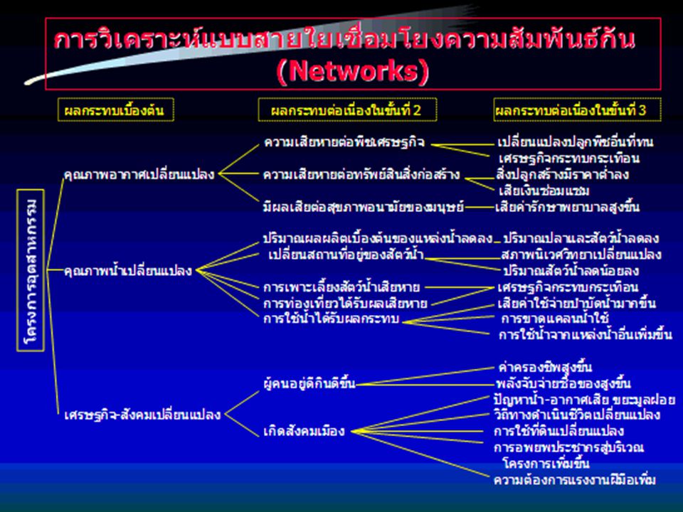
การวิเคราะห์แบบสายใยเชื่อมโยงความสัมพันธ์กัน
(Networks) หลักการ: วิธีนี้เป็นการรวมกิจกรรมต่างๆของโครงการ เพื่อสร้างเป็นแผนผังสายใยเชื่อมโยงติดต่อกัน บอกถึงสาเหตุสภาวะแวดล้อมและผลกระทบ โดยคำนึงผลกระทบโดยตรงและผลกระทบแอบแฝงของโครงการ แต่ถ้าเป็นโครงการใหญ่มีสายใยมากจะมีข้อยุ่งยากมาก ดังนั้นจึงใช้ได้เฉพาะโครงการที่มีกิจกรรมไม่มาก และกิจกรรมแต่ละอันมีผลกระทบไม่มากนัก สายใยนี้เมื่อเขียนออกเสร็จแล้วจะแสดงคล้ายรูปต้นไม้มีสาขาแตกแขนง เรียกว่า ต้นไม้แห่งผลกระทบ (Impact tree) ผลกระทบ ขั้นที่ 1 ขั้นที่ ขั้นที่ ขั้นที่ ขั้นที่ 5 กิจกรรมของโครงการ องค์ประกอบของกิจกรรม
 หลักการ: วิธีนี้เป็นการรวมกิจกรรมต่างๆของโครงการ เพื่อสร้างเป็นแผนผังสายใยเชื่อมโยงติดต่อกัน บอกถึงสาเหตุสภาวะแวดล้อมและผลกระทบ โดยคำนึงผลกระทบโดยตรงและผลกระทบแอบแฝงของโครงการ แต่ถ้าเป็นโครงการใหญ่มีสายใยมากจะมีข้อยุ่งยากมาก ดังนั้นจึงใช้ได้เฉพาะโครงการที่มีกิจกรรมไม่มาก และกิจกรรมแต่ละอันมีผลกระทบไม่มากนัก สายใยนี้เมื่อเขียนออกเสร็จแล้วจะแสดงคล้ายรูปต้นไม้มีสาขาแตกแขนง เรียกว่า ต้นไม้แห่งผลกระทบ (Impact tree) ผลกระทบ. ขั้นที่ 1 ขั้นที่ 2 ขั้นที่ 3 ขั้นที่ 4 ขั้นที่ 5. กิจกรรมของโครงการ. องค์ประกอบของกิจกรรม.")
59
การใช้แบบจำลองทางคณิตศาสตร์ (Simulation [mathematical] modeling)
วิธีการสมมติสถานการณ์และทางเลือกต่างๆ เช่น ประสิทธิภาพของระบบบำบัดต่างๆกัน แล้วพิจารณาระดับผลกระทบที่อาจเกิดขึ้นได้ง่าย วิธีนี้หากมีความรู้ทางคณิตศาสตร์และเทคโนโลยีทางคอมพิวเตอร์ ก็จะทำให้ประหยัดทั้งเวลาและค่าใช้จ่าย เมื่อเปรียบเทียบการจำลองทางกายภาพที่ทดลองในห้องปฏิบัติการ ตัวอย่าง การประเมินผลกระทบด้านการกระจายตัวของอากาศเสียจากแหล่งกำเนิดเพื่อหาความเข้มข้นของมลสารในบริเวณท้ายลมที่ระยะทางต่างๆ การประเมินผลกระทบด้านคุณภาพน้ำและปริมาณน้ำในแม่น้ำ ที่สมมติว่ามีการปล่อยมลสารจากแหล่งกำเนิดเพื่อหาความเข้มข้นของมลสารในบริเวณที่ห่างออกไปตามระยะทาง
![การใช้แบบจำลองทางคณิตศาสตร์ (Simulation [mathematical] modeling)](http://slideplayer.in.th/slide/1926101/7/images/59/%E0%B8%81%E0%B8%B2%E0%B8%A3%E0%B9%83%E0%B8%8A%E0%B9%89%E0%B9%81%E0%B8%9A%E0%B8%9A%E0%B8%88%E0%B8%B3%E0%B8%A5%E0%B8%AD%E0%B8%87%E0%B8%97%E0%B8%B2%E0%B8%87%E0%B8%84%E0%B8%93%E0%B8%B4%E0%B8%95%E0%B8%A8%E0%B8%B2%E0%B8%AA%E0%B8%95%E0%B8%A3%E0%B9%8C+%28Simulation+%5Bmathematical%5D+modeling%29.jpg "วิธีการสมมติสถานการณ์และทางเลือกต่างๆ เช่น ประสิทธิภาพของระบบบำบัดต่างๆกัน แล้วพิจารณาระดับผลกระทบที่อาจเกิดขึ้นได้ง่าย วิธีนี้หากมีความรู้ทางคณิตศาสตร์และเทคโนโลยีทางคอมพิวเตอร์ ก็จะทำให้ประหยัดทั้งเวลาและค่าใช้จ่าย เมื่อเปรียบเทียบการจำลองทางกายภาพที่ทดลองในห้องปฏิบัติการ. ตัวอย่าง. การประเมินผลกระทบด้านการกระจายตัวของอากาศเสียจากแหล่งกำเนิดเพื่อหาความเข้มข้นของมลสารในบริเวณท้ายลมที่ระยะทางต่างๆ. การประเมินผลกระทบด้านคุณภาพน้ำและปริมาณน้ำในแม่น้ำ ที่สมมติว่ามีการปล่อยมลสารจากแหล่งกำเนิดเพื่อหาความเข้มข้นของมลสารในบริเวณที่ห่างออกไปตามระยะทาง.")
60
ข้อดีข้อเสียของแต่ละวิธีการประเมิน
การตั้งคณะกรรมการเฉพาะกิจ -ให้ข้อมูลกว้างๆเปรียบเทียบทางเลือกพื้นที่แต่ละแห่ง เข้าใจง่ายทั้งระดับตัดสินใจและสาธารณชน -ไม่มีความแน่นอน เพราะขึ้นกับคณะกรรมการเป็นหลัก และต้องมีผู้เชี่ยวชาญครบทุกด้าน ซึ่งอาจเกิดความเกรงใจ ขัดแย้ง สรุปผลกระทบไม่ได้ การใช้แผนภาพซ้อน -เข้าใจง่าย เพราะแสดงด้วยภาพ -ใช้ในการคัดเลือกที่ตั้งโครงการที่ดี -แสดงเฉพาะผลกระทบโดยตรงเท่านั้น -ไม่ได้แสดงถึงระยะเวลาของผลกระทบ หรือโอกาสที่จะเกิดผลกระทบ การเช็ครายการ -เข้าใจง่ายและใช้ง่าย -ดีสำหรับการเลือกพื้นที่ตั้งโครงการและการจัดลำดับความสำคัญ -ไม่ได้ให้ความแตกต่างระหว่างผลกระทบโดยตรงและโดยอ้อม -ไม่เชื่อมโยงระหว่างกิจกรรมและผลกระทบ การใช้เมตริกซ์ -เชื่อมโยงกิจกรรมกับผลกระทบ -แสดงผลภาพรวมทั้งหมดทุกกิจกรรม -ยากที่จะให้ความแตกต่างระหว่างผลกระทบโดยตรงและโดยอ้อม -มักจะเกิดการนับผลกระทบซ้ำซ้อนกัน การวิเคราะห์แบบสายใยเชื่อมโยงความสัมพันธ์กัน -เชื่อมโยงระหว่างกิจกรรมไปสู่ผลกระทบได้ชัดเจน และครอบคลุมทั้งผลกระทบโดยตรงและโดยอ้อมได้ เพราะมีผลกระทบแสดงได้หลายขั้น -จะยุ่งยากมากถ้าพิจารณาถึงผลกระทบขั้นลึกๆ คือขั้นที่ 3-4-5 การใช้แบบจำลองทางคณิตศาสตร์ -สามารถสมมติสถานการณ์ต่างๆ เพื่อหาผลกระทบได้โดยง่าย -ใช้เวลา ค่าใช้จ่าย เทคโนโลยีขั้นสูง และบุคลากรต้องมีประสบการณ์ด้วย

61
ปัจจัยการเลือก วิธีการประเมิน
ประเภทและขนาดของโครงการ ประเภทของการเลือกที่จะทำการประเมิน ลักษณะของผลกระทบ เช่น ผลกระทบโดยตรง หรือโดยอ้อม ประสบการณ์ของทีมงาน ประเมินในวิธีที่จะเลือกใช้ ประสบการณ์ของเจ้าของโครงการในประเภท/ขนาดโครงการ สิ่งสนับสนุน เช่น ค่าใช้จ่าย ข้อมูลพื้นฐาน เวลา และบุคลากร การมีส่วนร่วมของชุมชน ประชาชน หน่วยงาน

62
Let it flow by the way of life, depend on behavior!

งานนำเสนอที่คล้ายกัน


>")


>")


>")